The Salt Marsh Trail was one of those places I’d always heard about but never got around to visiting. It seemed like just another trail, nothing special.
Until one day, with nothing better to do, I thought, “Why not?”
So, I grabbed my bike and headed down the path, not expecting much. But wow, was I in for a surprise!
The trail quickly became one of my favorite places to unwind and escape the daily grind. It’s the spot where the world just seems to slow down, with waves gently lapping against the shore, birds swooping overhead, and the salty breeze clearing your mind.
It became a personal mini-vacation from the hustle and bustle. If you’ve ever been curious about the Salt Marsh Trail, trust me—you need to explore it.
It’s the perfect place to reconnect with nature and find a little slice of peace right here in Nova Scotia!
About Salt Marsh Trail
Media credit: discoverhalifax
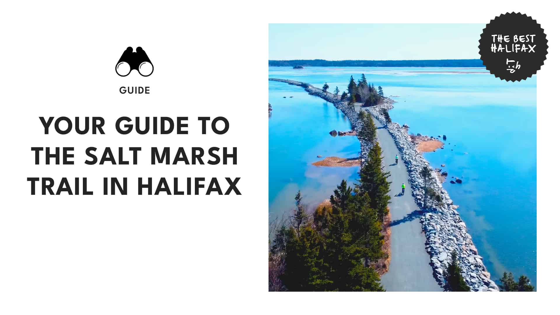
The Salt Marsh Trail is part of the old Musquodoboit railroad, now transformed into a lovely stretch of the Trans Canada Trail. Whether you’re hiking, biking, cross-country skiing, or just out for a leisurely stroll, this trail’s got something for everyone.
The trail features a cool causeway through the Cole Harbour salt marsh. Here, you’ll be treated to breathtaking views, fun interpretive signs, and plenty of wildlife.
As a part of the “Great Trail,” the Salt Marsh Trail spans 9 km and connects to two other exciting trails: the Atlantic View Trail and the Shearwater Flyer. This connectivity makes it a versatile destination for outdoor enthusiasts.
The trail’s 6.5 km one-way stretch is perfect for those looking for a leisurely walk or a smooth bike ride. With its flat and easy-to-navigate terrain, it’s accessible to everyone, whether you’re a seasoned hiker or just out for a casual walk.
And if you’re a stickler for numbers, distance markers every kilometer help track your progress.
The Salt Marsh Trail is well-equipped to make your visit comfortable. You’ll find parking, toilets, benches, dog bags, and garbage cans along the way. Everything you need to make your outdoor adventure enjoyable and hassle-free.
The Salt Marsh Trail is maintained by the Cole Harbour Parks and Trails Association, who keep the trail clean and safe. They also provide helpful information panels along the way.
How to Get to the Salt Marsh Trail
Media credit: robichaud.jpg
If you’re going from downtown Halifax, getting to the Salt Marsh Trail is a breeze by car and takes around 20-25 minutes.
You can start by heading along Cunard St and Gottingen St, then cross the Angus L. Macdonald Bridge to Windmill Rd/Nova Scotia Trunk 7 E in Dartmouth. This leg will take approximately 7 minutes and cover about 3.4 km.
Next, take Portland St to Bissett Rd/NS-322 N in Cole Harbour, a drive of about 15 minutes over 8.4 km. Then, turn right onto Bissett Rd/NS-322 N, and in just 4 minutes (3.6 km), you’ll arrive at the Salt Marsh Trail.
Upon arrival, you’ll find the main starting point at Bissett Road with a designated parking lot. Do note that this lot can get quite crowded, particularly on weekends.
As a backup, there’s an overflow lot just 250 meters around the corner, which connects directly to the trail.
This alternative parking option makes it easy to access the Salt Marsh Trail, and it’s conveniently close to the Cole Harbour Heritage Park and other nearby pathways.
Unfortunately, public transport doesn’t reach the trail, but if you’re up for a bit of exercise, biking there is an option. It’ll take you roughly an hour to an hour and a half to reach the trail by bike, depending on your pace.
Best Time to Go
Media credit: missmaddie
The best time to visit the Salt Marsh Trail is from August through September. This period offers ideal conditions for birding, cross-country skiing, and hiking.
During these months, the trail is usually less crowded, allowing for a peaceful and private exploration.
What to Do on the Salt Marsh Trail
Hike
Please embed: https://www.instagram.com/p/C-eIKIhpi0b/?img_index=1
Media credit: life_of_mandu
The Salt Marsh Trail is a hiker’s dream! The trail is flat and easy, perfect for all levels of experience. Whether you’re looking for a leisurely walk or a longer hike, you can enjoy the trail at your own pace.
The route is also lined with small scenic sites, including four picturesque bridges that cross the marsh.
For a longer adventure, hike the full 13 km round trip and take in the changing views. If you’re in the mood for even more, you can connect to the Shearwater Flyer and Atlantic View Trails for a 25 km trek.
Bike
Media credit: moments_hfx
The Salt Marsh Trail is an excellent route for biking. The flat, compacted surface makes for a smooth and enjoyable ride.
You can easily explore the path and take in the beautiful sights of the salt marsh. For those up for a bit more, the round trip offers plenty of scenery, and you can extend your ride to linking up with the Shearwater Flyer and Atlantic View Trails.
While the trail is mostly flat and easy to navigate, keep in mind there might be some uneven sections.
And remember, during peak times, parking might be a bit tight, so plan accordingly!
Birdwatch
Media credit: healing_on_the_fly
Bird enthusiasts will find the Salt Marsh Trail a fantastic route for spotting various bird species.
The salt marsh is home to a variety of feathered friends. Just keep your eyes and ears open as you walk or bike along the trail.
You might see sandpipers scurrying around or waterfowl gliding across the marsh. Don’t forget your binoculars and bird guide!
Ski or trek
Media credit: ruairidh1
The Salt Marsh Trail is also a great place for cross-country skiing and snowshoeing when the snow falls (conditions permitting). The snow-covered landscape turns the trail into a serene winter wonderland.
Before you head out, just check the trail conditions to make sure it’s safe and suitable for your winter activities.
Watch out for points of interest
Media credit: sheldonmiller902
As you stroll along the Salt Marsh Trail, keep your eyes peeled for some standout settings that make this hike truly special.
Whether you’re snapping photos, taking a break, or simply soaking in the views, these key points will add a little extra magic to your adventure.
Rosemary’s Way
Just 600 meters from the main parking lot, Rosemary’s Way is the perfect area to kick back and take in the stunning views. You’ll find benches tucked away where you can sit and soak up the beauty of the salt marsh.
Information Kiosk
Continue 200 meters past Rosemary’s Way, and you’ll arrive at the Information Kiosk. This is where you can dive into some local history while taking a breather on a nearby bench.
The kiosk area also features basic toilet facilities and a covered picnic area. It’s an ideal location for a quick snack or to watch sandpipers dabbling in the wet sand.
Bald Eagle Bridge
Just beyond the kiosk area, you’ll find the Bald Eagle Bridge. This memorial bridge is a tribute to the area’s natural and historical heritage and a nice place to pause and reflect before continuing your journey.
Canada Goose Bridge
300 meters from the Bald Eagle Bridge, the Canada Goose Bridge offers a view of a marshy area frequently visited by waterfowl. It’s a great location for bird watchers and anyone who enjoys observing wildlife in their natural habitat.
Treasured Wetlands Bench
200 meters past the Canada Goose Bridge, you’ll come across the Treasured Wetlands bench, a title given by Ducks Unlimited. This ultra-scenic spot is perfect for taking photos.
Ready Aye Ready Bridge
Just 1.3 kilometers from the Canada Goose Bridge, the Ready Aye Ready Bridge is known for its fast-flowing current. It’s a great area to watch the water rush beneath you and enjoy the dynamic landscape of the marsh.
Conrad Brothers Bridge
The final bridge on the trail, the Conrad Brothers Bridge, is 750 meters beyond the Ready Aye Ready Bridge. It marks the end of the overwater section of the trail and is a fitting conclusion to the series of beautiful bridges.
End of the Trail
At the end of the trail, you’ll find a bench with a spectacular view. From here, the trail continues through 1.7 kilometers of tranquil woodlands before opening up to connect with the Atlantic View Trail.
The popular Lawrencetown Beach is just 1.5 kilometers further and is worth a visit if you’re up for more exploring.